Shandong Fengtu IOT Technology Co., Ltd
Sales Manager:Ms. Emily Wang
Cel,Whatsapp,Wechat:+86 15898932201
Email:info@fengtutec.com
Add:No. 155 Optoelectronic Industry Accelerator, Gaoxin District, Weifang, Shandong, China


Sales Manager:Ms. Emily Wang
Cel,Whatsapp,Wechat:+86 15898932201
Email:info@fengtutec.com
Add:No. 155 Optoelectronic Industry Accelerator, Gaoxin District, Weifang, Shandong, China
time:2026-04-24 09:23:00 source:Weather Station viewed:159 time
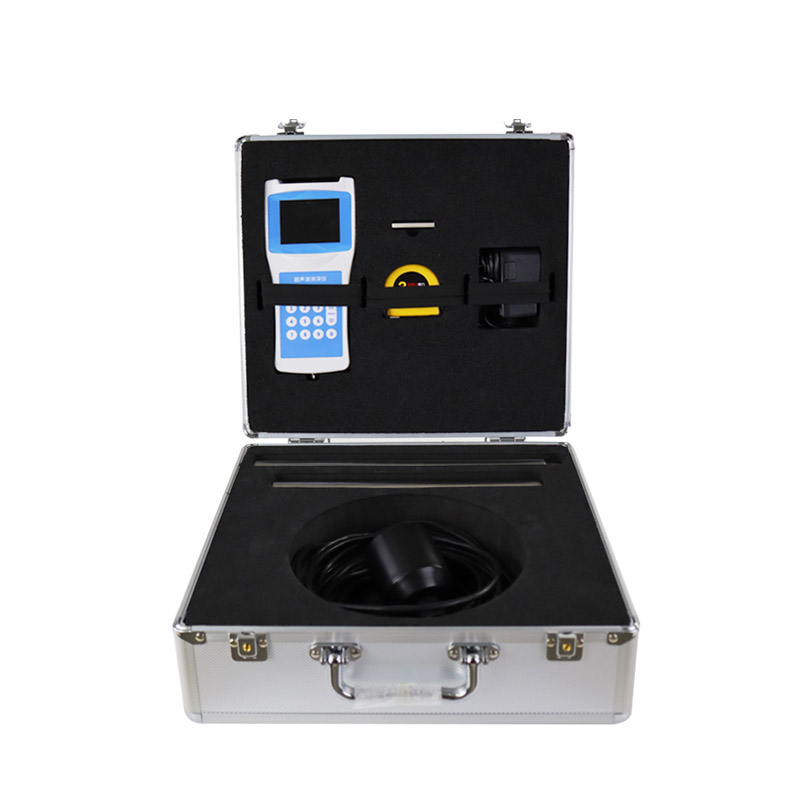
Handheld Digital Depth Sounder operates based on the principle of echo sounding: a transducer emits high-frequency acoustic waves underwater and receives the returning echoes, automatically calculating the water depth based on the elapsed round-trip time. It is suitable for use in various bodies of water—including reservoirs, lakes, rivers, and shallow seas—and is capable of maintaining stable measurements even in water currents reaching speeds of up to 5 m/s.
The core operating principle of Handheld Digital Depth Sounder is echo sounding. The instrument utilizes an ultrasonic transducer to emit high-frequency acoustic pulses underwater. These acoustic waves propagate through the water at a speed of approximately 1,500 meters per second; upon reaching the seabed or encountering an underwater obstacle, they are reflected back. The transducer receives these reflected echoes, and a microprocessor precisely records the total round-trip time—from emission to reception—to automatically calculate the water depth using the formula H = V × T / 2. Since the propagation speed of ultrasonic waves in water is influenced by temperature, certain models are equipped with temperature sensors to perform real-time sound velocity corrections, thereby further enhancing measurement accuracy.
In terms of hardware configuration, the portable Handheld Digital Depth Sounder primarily integrates an ultrasonic transducer, a data processor, a liquid crystal display (LCD) screen, and a power supply system. The transducer employs ceramic sensing elements responsible for both the emission and reception of acoustic waves; it functions optimally when immersed in water to a depth of just 5 to 10 centimeters. The device utilizes large-scale integrated circuits, featuring a highly integrated ultrasonic transceiver circuit design that ensures both measurement reliability and low power consumption. The LCD screen displays real-time depth readings, while select models offer an optional data storage module capable of exporting measurement data in CSV or Excel formats.
Automatic range-tracking measurement constitutes a core functionality of this device. Upon initiating a measurement, the instrument automatically determines the current depth range based on the initial echo signal, subsequently adjusting the transmission power and gain parameters accordingly—eliminating the need for manual range configuration. This design streamlines the measurement process into a simple "one-touch" operation, making it ideally suited for aquatic environments where deep and shallow zones alternate frequently. Furthermore, the device incorporates self-stabilizing measurement technology capable of effectively suppressing interference caused by surface ripples and wind-driven waves, thereby ensuring the stable acquisition of accurate depth data even under flow conditions reaching speeds of up to 5 meters per second. In terms of application fields, the Handheld Digital Depth Sounder covers a wide range of scenarios, including hydrological monitoring, aquaculture, marine research, and waterway engineering. In the realm of hydrological monitoring, it is utilized for river cross-section measurements, reservoir capacity estimation, and comprehensive lake depth surveys. For aquaculture, it assists farmers in real-time monitoring of pond depth fluctuations, providing data-driven support for decisions regarding feeding and aeration. In waterway engineering, it is employed for calculating dredging volumes and mapping underwater topography. Furthermore, the device can be integrated with current meters and sediment samplers, enabling simultaneous depth measurement, velocity profiling, and sediment sampling in a single pass, thereby significantly enhancing operational efficiency. This comprehensive combination of functions establishes it as an essential tool for water depth measurement.
The rainfall monitoring station is small in size, easy to install and maintain, and inexpensive. It is very suitable for mountain flood early warning, hydrological forecasting and other work. It realizes real-time collection, remote transmission and online monitoring of rainfall data through hardwar...
Soil moisture monitoring stations are vital to agricultural cultivation, directly affecting the growth and ultimate yield of crops. Such monitoring stations can comprehensively and scientifically monitor small changes in soil moisture and ensure that the data provided are true and reliable. The data...
rain gauge how does it work Falling rainwater is collected in a container and measured to determine the depth of precipitation occurring per unit area, usually measured in millimeters....
A rain monitor is a specialized device that can be used to monitor and record rainfall at different locations. The main components are rainfall sensors and data output devices.The following are the main features of the rain monitor and its working principle:Features: The rainfall monitor is characte...


 Skype
Skype
 whatsapp
 mail
mail