Shandong Fengtu IOT Technology Co., Ltd
Sales Manager:Ms. Emily Wang
Cel,Whatsapp,Wechat:+86 15898932201
Email:info@fengtutec.com
Add:No. 155 Optoelectronic Industry Accelerator, Gaoxin District, Weifang, Shandong, China


Sales Manager:Ms. Emily Wang
Cel,Whatsapp,Wechat:+86 15898932201
Email:info@fengtutec.com
Add:No. 155 Optoelectronic Industry Accelerator, Gaoxin District, Weifang, Shandong, China
time:2025-06-24 09:25:51 source:Weather Station viewed:630 time
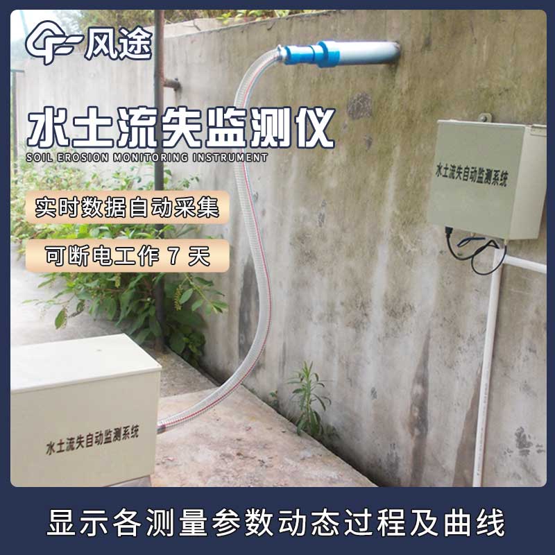
Mining operations are like a double-edged sword: while fueling economic growth, they leave behind environmental challenges, with slope instability and soil erosion being the most pressing. Mountain landslides are no trivial matter—accidents such as equipment burial and worker entrapment occur frequently. When rainwater erodes the slopes, massive sediments flow into rivers, clogging downstream reservoirs and drastically reducing soil fertility in surrounding farmlands. These issues have driven mining professionals to seek solutions, leading to the introduction of Soil Erosion Monitoring systems for mine slope surveillance.
How the System Works
This system acts as a 24/7 "soil-water observer," relying on sensors as its "eyes and ears":
Rainfall sensors installed on slopes function like accountants tracking precipitation, precisely recording rainfall duration and intensity.
Flow sensors in runoff ditches monitor water velocity and volume, detecting sudden surges immediately.
Soil moisture and erosion sensors buried in the ground continuously assess soil "health," triggering alerts when water content anomalies or erosion signs are detected.
Data Flow and Processing
Data from sensors is aggregated by a collection unit, which organizes the information like a meticulous clerk. It then transmits data via 4G or wireless networks to a monitoring center’s processing platform. Mine technicians can view real-time slope conditions remotely, eliminating the need for on-site inspections.
Practical Applications and Impacts
Real-time Early Warning
Traditional manual inspections were inefficient and unable to respond to sudden storms. The automated system now notifies technicians of any soil erosion changes instantly. For example, increased runoff after heavy rain prompts immediate reinforcement, nipping risks in the bud.
Scientific Slope Stability Assessment
Instead of relying on experience, technicians use long-term monitoring data and professional models to calculate slope safety factors. Analyzing soil erosion and moisture trends helps predict landslide-prone areas, enabling proactive precautions.
Targeted Ecological Restoration
Post-mining restoration previously relied on intuition, yielding inconsistent results. Now, data guides strategies: severe erosion areas get deep-rooted tree species, and retaining walls are built in critical spots, optimizing resource allocation for better outcomes.
Remote Monitoring and Alerts
Technicians can access real-time data via mobile devices from anywhere. The system sets safety thresholds—if metrics like runoff exceed limits, it sends instant notifications via SMS or calls, ensuring preemptive action.
Soil Erosion Monitoring systems have transformed mine management, shifting from reactive measures to data-driven proactive strategies, and balancing economic development with environmental protection.
The rainfall monitoring station is small in size, easy to install and maintain, and inexpensive. It is very suitable for mountain flood early warning, hydrological forecasting and other work. It realizes real-time collection, remote transmission and online monitoring of rainfall data through hardwar...
What are the benefits of installing a regional automatic weather station? A regional automatic weather station can realize the functions of collecting, processing and storing weather data, playing an important role in weather analysis and providing a reliable basis for local weather warning. It has...
With data collectors, sensors, wireless transmission devices, mounting brackets and software platforms, the wireless automatic weather station is an integrated IoT weather monitoring system that not only automatically collects and records weather environment and soil moisture conditions, but also tr...
The Viscosity Sensor is an inline device designed for measuring fluid viscosity; it utilizes tuning fork resonance technology to deliver rapid response times. Capable of continuously monitoring changes in fluid viscosity, this device is widely deployed in the quality control stages of producti...


 Skype
Skype
 whatsapp
 mail
mail