Shandong Fengtu IOT Technology Co., Ltd
Sales Manager:Ms. Emily Wang
Cel,Whatsapp,Wechat:+86 15898932201
Email:info@fengtutec.com
Add:No. 155 Optoelectronic Industry Accelerator, Gaoxin District, Weifang, Shandong, China


Sales Manager:Ms. Emily Wang
Cel,Whatsapp,Wechat:+86 15898932201
Email:info@fengtutec.com
Add:No. 155 Optoelectronic Industry Accelerator, Gaoxin District, Weifang, Shandong, China
time:2024-12-06 09:32:12 source:Weather Station viewed:719 time
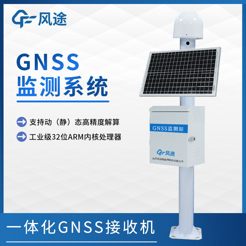
The GNSS (Global Navigation Satellite System) monitor is a displacement measuring device based on the global navigation satellite system. When in operation, the antenna of the monitor fully receives satellite signals, which contain crucial information such as satellite orientation and time. The receiver quickly amplifies, filters, and demodulates the signals to remove interference and extract the effective content. Then, the data processing unit uses professional algorithms to accurately calculate the three-dimensional coordinates of the location. The power supply provides stable power throughout the process to ensure the smooth operation of the equipment.
In the field of geodesy, when drawing maps and conducting engineering surveys, it can quickly lock the coordinates of control points with its high-precision advantage, strengthening the foundation of the preliminary work. In terms of geological disaster monitoring, by setting up monitoring points in areas prone to landslides and subsidence, it continuously tracks the slightest ground displacements. Once any abnormality occurs, it will immediately send out warnings, seizing the initiative for emergency rescue and disaster relief. In transportation, it provides precise navigation for vehicles and ships, plans the optimal routes, reduces the risk of accidents, and improves traffic efficiency. Its existence is not only a demonstration of scientific and technological achievements but also a powerful driving force for promoting the steady development of multiple industries.
The GNSS monitoring station for mine slopes is a crucial technical means to ensure the safe production of mines. This system mainly consists of a data acquisition terminal, a network transmission terminal, and a management center terminal.The various sensors at the data acquisition terminal, such as...
Irrigation channel flow monitoring realizes continuous dynamic monitoring of water flow in irrigation channels through the deployment of various measuring equipment and data collection technologies. Based on flow monitoring data, precise irrigation plans can be formulated by combining indicators suc...
Radar water level monitoring station manufacturer - Windway Technology, a domestic manufacturer of radar water level monitoring station, can choose the right products according to different engineering needs in order to meet the needs of different areas of water level observation accuracy and reliab...
gas sensors are devices that detect the presence of various gases, detect a particular gas and measure whether that gas is present near the sensor or its amount in the air....


 Skype
Skype
 whatsapp
 mail
mail