Shandong Fengtu IOT Technology Co., Ltd
Sales Manager:Ms. Emily Wang
Cel,Whatsapp,Wechat:+86 15898932201
Email:info@fengtutec.com
Add:No. 155 Optoelectronic Industry Accelerator, Gaoxin District, Weifang, Shandong, China


Sales Manager:Ms. Emily Wang
Cel,Whatsapp,Wechat:+86 15898932201
Email:info@fengtutec.com
Add:No. 155 Optoelectronic Industry Accelerator, Gaoxin District, Weifang, Shandong, China
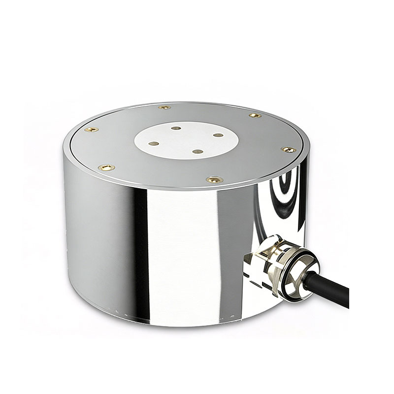
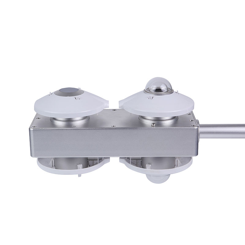
Model:FT-JB2H
Brand:fengtu
1、Road Ice Sensor Product Introduction
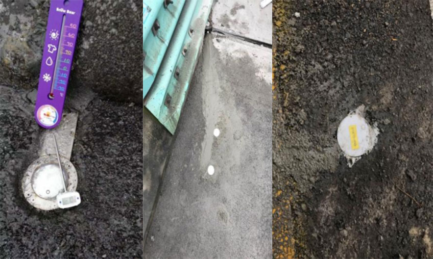
Road Ice Sensor can accurately detect the thickness of ice, snow and water on the road surface, and determine the existence of ice and ice thickness in real time.Road Ice Sensor employs unique microwave detection technology and a multi-parameter fusion algorithm. It monitors the surface of the sensor—specifically detecting the output values corresponding to various material states and environmental conditions, such as ice formation, ice thickness, water accumulation, and temperature—and integrates temperature detection and compensation technologies to provide precise monitoring of icing conditions and ice thickness.
The sensor is capable of simultaneously outputting both icing pre-warning and alarm signals; it can also be paired with temperature and humidity sensors to facilitate comprehensive, multi-faceted environmental monitoring of road surfaces.
The online icing monitoring sensor consists of an electronic module—powered by MCU processing technology—and a sensing probe. A PT1000 platinum resistance element is embedded within the probe to provide temperature input to the sensor system.
Temperature compensation is achieved by utilizing the PT1000 sensor to acquire real-time temperature data; this temperature signal is then used to adjust the calibration curves within the MCU, thereby significantly enhancing the accuracy of ice detection.
Characterized by its simple structure, ease of installation, and strong anti-interference capabilities, this online road condition monitoring sensor is ideally suited for monitoring road icing on highways, airport runways, bridges, and urban roadways. It serves as a critical solution for various Internet of Things (IoT) applications, including intelligent transportation systems and smart city initiatives.
2、Road Ice Sensor Product Features
Utilizes microwave perturbation detection technology
Provides ice formation warnings and alarms
Multi-parameter fusion algorithms enhance detection accuracy
Monitors road surface conditions: dry, wet (standing water), ice, snow, ice thickness, and high-temperature alerts
Enhances road safety
Compact sensor size facilitates installation; supports diverse mounting methods
Unique structural design withstands extreme pressure and is highly durable
The optimal choice for various de-icing systems
3、Road Ice Sensor Application Areas
Expressways, Airports, Bridges, Urban Interchanges, Scenic Area Roads, Mountain Roads, Novel Road De-icing Systems
4、Road Ice Sensor Technical Specifications
Detection Parameters: Icing, Ice Thickness, Water Film Thickness, Dry, Wet/Standing Water, Snow, Pavement Temperature, High-Temperature Warning, Freezing Point (Optional), Salt Concentration (Optional)
Icing Detection Range: 0.2 mm – 10 mm
Minimum Ice Thickness: 0.2 mm
Maximum Ice Thickness: 10 mm
Ice Alarm Threshold: 0.2 – 10 mm (Adjustable)
Measurement Accuracy: ±2% FS
Water Film Thickness: 0 – 4 mm (Optional)
Measurement Accuracy: ±0.5 mm
Freezing Point: 0 – -20°C
Accuracy: ±1°C
Communication Protocol: Modbus RTU
Operating Temperature: -40°C – 85°C
Storage Temperature: -55°C – 85°C
Operating Voltage: DC 3.3V or DC 5 – 30V
Operating Humidity: 0 – 100% RH
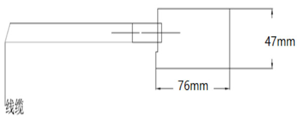
Dimensions: Φ76 × 47 mm
IP Rating: IP68
Visibility in tunnels is something to be concerned about.Visibility inside tunnels is low, especially at entrances and exits, so drivers should always stay alert and turn on their headlights in advance so that they can stay safe even in low visibility conditions. At the same time, they should pay at...
Measuring wind speed data is one of the most basic and important tasks in meteorological observation. As a key meteorological observation instrument, wind speed sensor is used to measure the wind speed in the environment for weather prediction, weather warning, building design and other related fiel...
Fengtu, as a manufacturer of Online Ammonia Nitrogen analyzers, has launched two ammonia nitrogen detectors, both of which are common instruments in the market.Firstly, the FT-ZS5 Online Water Quality AnalyzerIt integrates a water quality ammonia nitrogen sensor, a measurement module, an...
Water Level Monitoring Station is a technological facility that uses low-power intelligent sensing devices as its core to continuously monitor the water levels of rivers and lakes,This system provides decision support for flood control, disaster reduction, and water resource management by accurately collecting hydrological data....


 Get a Free Quote
 Skype
Skype
 whatsapp
 mail
mail