Shandong Fengtu IOT Technology Co., Ltd
Sales Manager:Ms. Emily Wang
Cel,Whatsapp,Wechat:+86 15898932201
Email:info@fengtutec.com
Add:No. 155 Optoelectronic Industry Accelerator, Gaoxin District, Weifang, Shandong, China


Sales Manager:Ms. Emily Wang
Cel,Whatsapp,Wechat:+86 15898932201
Email:info@fengtutec.com
Add:No. 155 Optoelectronic Industry Accelerator, Gaoxin District, Weifang, Shandong, China
time:2026-03-25 10:24:26 source:Weather Station viewed:305 time
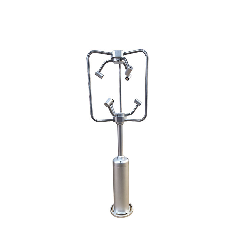
3D Ultrasonic Anemometer Based on the principle of ultrasonic time-of-flight difference, this device simultaneously outputs wind speed data for the X, Y, and Z axes, as well as horizontal and vertical wind direction data. Designed for all-weather operation, it can be deployed in various settings—including urban areas, wind power generation sites, bridges, and marine vessels—to provide high-precision, three-dimensional wind field measurements.
3D Ultrasonic Anemometer The instrument utilizes the ultrasonic time-of-flight difference method to measure wind fields. It employs three pairs of mutually orthogonal ultrasonic transducers to measure the time difference in the propagation of ultrasonic pulses across different directions. When airflow moves along a specific axis, a time difference occurs between ultrasonic pulses traveling in the downwind and upwind directions; by calculating this difference, the wind speed component along that specific axis can be determined. The device's internal algorithms simultaneously process data from all three axes to output wind speeds for the X, Y, and Z axes, while also synthesizing the combined horizontal wind direction and speed, as well as the vertical wind speed and direction.
This instrument requires no moving mechanical parts, thereby eliminating the failure risks—such as bearing wear, icing, or dust accumulation—typically associated with traditional wind cups or wind vanes. Its housing and structural components are constructed from corrosion-resistant materials, making the device highly adaptable to harsh outdoor environments characterized by high humidity, salt spray, and intense UV radiation; it can operate continuously under extreme weather conditions, including severe cold, high temperatures, and strong winds. Installation is straightforward: the device simply needs to be mounted on a pole or bracket and connected to a data acquisition system via a standard interface; it requires no periodic calibration or mechanical maintenance.
In terms of data output, the 3D Ultrasonic Anemometer provides comprehensive information regarding the entire vector wind field. For the horizontal plane, it outputs the synthesized wind speed and direction, serving the needs of routine meteorological observation and environmental monitoring; for the vertical plane, it outputs vertical wind speed data, providing critical parameters for atmospheric boundary layer research and turbulent flux calculations. For wind turbines, the device measures the 3D wind field immediately upstream of the turbine, thereby facilitating yaw control and power forecasting; for bridges and high-rise buildings, vertical wind speed data aids in structural wind-induced vibration analysis; and in airport environments, the device is capable of detecting low-altitude wind shear and vertical air currents, thereby enhancing safety during aircraft takeoffs and landings. By employing the ultrasonic transit-time method, measurement results remain unaffected by instantaneous fluctuations in atmospheric temperature, humidity, or pressure, maintaining a linear response across the entire measurement range. The device features an adjustable sampling frequency, enabling it to capture rapid changes associated with wind gusts and turbulence. Data output supports both digital and analog signals, facilitating seamless integration with weather stations, automated monitoring systems, or industrial control platforms. In practical deployments, the device can operate independently or be integrated with other instruments—such as road surface condition detectors and visibility sensors—to form a comprehensive weather station, thereby providing reliable wind field data support for sectors such as urban management, traffic dispatch, and energy production.
The working principle of high frequency radar level meter:FM continuous wave radar level meter general principle is the radar to the top of the tank radiation electromagnetic waves, electromagnetic waves encountered in the medium when the reflection by the radar to receive, send and receive signals...
Micro weather stations have always been a good weather observation tool in the field of meteorology. This kind of weather station generally includes all kinds of sensors, data collectors and data processing units, which can monitor temperature, humidity, air pressure, wind speed, wind direction and...
Meteorological monitoring instrument manufacturers Fengtu is a professional enterprise engaged in the research, development, production, and sales of meteorological monitoring instruments. The company focuses on the promotion and application of meteorological monitoring equipment and related environmental solutions. Fengtu possesses a complete production chain, a strong technical team, and a comprehensive marketing system....
The air quality micro-monitoring station is an environmental protection device that is primarily used to monitor the quality of indoor and outdoor air. It provides real-time data on environmental indicators by measuring air quality parameters in the environment, such as PM2.5, PM10 and CO2, to deriv...


 Skype
Skype
 whatsapp
 mail
mail