Shandong Fengtu IOT Technology Co., Ltd
Sales Manager:Ms. Emily Wang
Cel,Whatsapp,Wechat:+86 15898932201
Email:info@fengtutec.com
Add:No. 155 Optoelectronic Industry Accelerator, Gaoxin District, Weifang, Shandong, China


Sales Manager:Ms. Emily Wang
Cel,Whatsapp,Wechat:+86 15898932201
Email:info@fengtutec.com
Add:No. 155 Optoelectronic Industry Accelerator, Gaoxin District, Weifang, Shandong, China
time:2024-12-18 09:36:22 source:Weather Station viewed:787 time
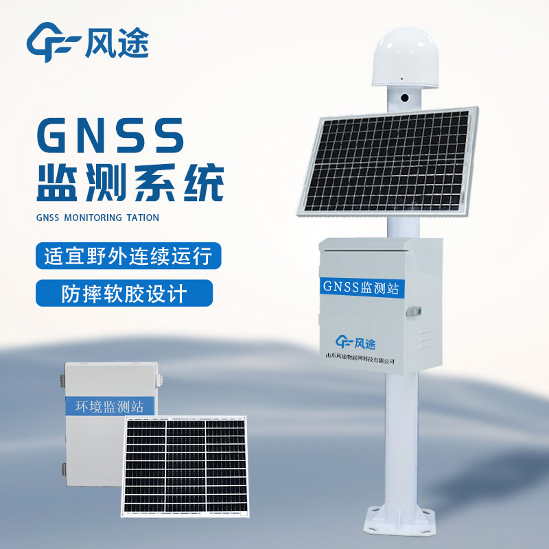
The GNSS Monitoring Station can detect potential dangers in a timely manner by monitoring mountain displacements with high precision. It can collect the three-dimensional coordinates of monitoring points on the mountain surface in real time, with an accuracy reaching the centimeter or even millimeter level. These monitoring points are distributed at key parts such as the slope surface and the edge of cracks, and continuously send position information at a set frequency. The displacement change of the collected coordinates is analyzed to calculate the displacement amount and rate. Once it exceeds the preset threshold, an alarm will be issued. For example, for a mountain monitoring point beside a highway in a certain mountainous area, if the horizontal displacement exceeds 10 centimeters within a short time and the rate accelerates, it indicates the risk of landslide.
The GNSS Monitoring Station is integrated with other monitoring means to comprehensively judge the stability of the mountain. When combined with the meteorological monitoring system, during heavy rainfall weather (such as the rainfall exceeding 50 millimeters per hour), if there is an obvious change in the mountain displacement at the same time, the system will raise the alarm level, because rainfall will increase the weight of the mountain and reduce the shear strength of the soil. At the same time, when used in conjunction with the internal monitoring equipment of the geotechnical body, the internal sensors measure parameters such as pore water pressure and earth pressure. When the pore water pressure rises and there is displacement at the monitoring points on the mountain surface, it more accurately indicates the danger of landslide.
This system has an alarm and emergency response mechanism. There are multiple levels of alarm thresholds. A yellow alarm is issued when the displacement amount is 5 - 10 centimeters, and a red alarm is issued when it exceeds 10 centimeters and the rate is fast. Once the alarm is triggered, it can automatically link to the emergency response, notify departments such as geological disaster prevention and traffic management and nearby residents, and also provide detailed displacement data to assist in the formulation of emergency rescue plans, effectively preventing the harm of mountain landslides.
Malodorous gases are a type of gaseous substances that can cause people unpleasant feelings. Industrial production, municipal sewage, sludge treatment, and waste disposal facilities are the main sources of malodorous gases.Malodorous gases are toxic to varying degrees to the human respiratory,...
Agricultural development will encounter some bad weather, such as typhoon, rainstorm, drought, hail, frost, etc., which will bring losses to agriculture. Setting up a meteorological and environmental monitoring system in farmland will help to improve the level of agro-meteorological environmental monitoring in the region, increase the yield of crops, and increase the ability to prevent disasters. With the development of smart agriculture, the model of weather station + Internet continues to develop, and the agricultural environment monitoring system will bring more development opportunities....
A soil moisture monitoring system is an automated system used to monitor soil moisture conditions, which can help farmers or agricultural researchers better understand soil moisture conditions in order to develop more effective irrigation schedules and crop management strategies.Soil moisture monito...
Mining operations are like a double-edged sword: while fueling economic growth, they leave behind environmental challenges, with slope instability and soil erosion being the most pressing. Mountain landslides are no trivial matter—accidents such as equipment burial and worker entrapment occur frequ...


 Skype
Skype
 whatsapp
 mail
mail