Shandong Fengtu IOT Technology Co., Ltd
Sales Manager:Ms. Emily Wang
Cel,Whatsapp,Wechat:+86 15898932201
Email:info@fengtutec.com
Add:No. 155 Optoelectronic Industry Accelerator, Gaoxin District, Weifang, Shandong, China


Sales Manager:Ms. Emily Wang
Cel,Whatsapp,Wechat:+86 15898932201
Email:info@fengtutec.com
Add:No. 155 Optoelectronic Industry Accelerator, Gaoxin District, Weifang, Shandong, China
time:2024-08-30 13:07:47 source:Weather Station viewed:927 time
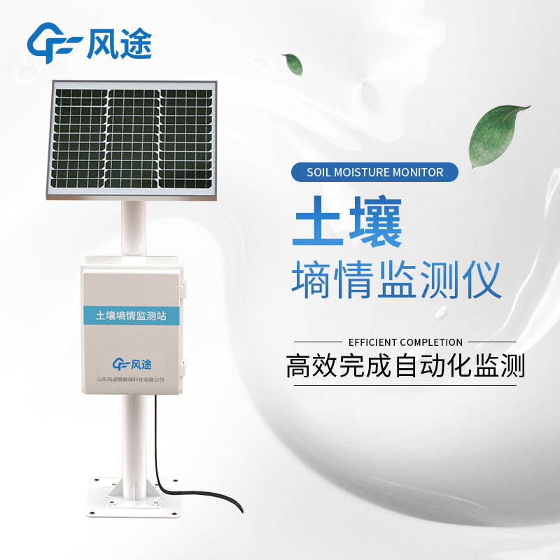
Soil is a key natural resource and is vital for crop growth. Crops are affected by dry or excessively wet soils, and economic and social development and climate change have exacerbated the problem of drought, leading to increased water scarcity and associated disaster losses. In hilly and forested areas, excessively wet soil can also lead to geologic hazards such as landslides and mudslides.
Soil moisture monitoring equipment provides critical data for agricultural drought relief, smart irrigation decisions and scientific research by tracking soil moisture content in real time. The system can also provide early warning before geological disasters occur, helping to reduce the losses caused by natural disasters and providing a scientific basis for disaster warning and soil and water conservation work.
Soil moisture monitoring equipment is a collection of moisture sensors, temperature sensors, high-definition cameras, rain gauges, power supply systems, data acquisition and transmission terminals, and protection tubes.
Soil moisture monitoring equipment can collect soil moisture, soil temperature, surface air temperature, rainfall in real time, and record the environmental image of the station through high-definition camera, so as to realize instant data collection and reporting. This integrated design not only improves monitoring efficiency, but also simplifies the operation process and reduces the complexity of operation and maintenance.
Real-time monitoring of soil moisture content helps assess the depth and activity area of the forest root system and guides the selection of tree species adapted to local soil and climate. By analyzing soil properties and moisture changes, geological disasters can be predicted, timely warnings can be given to reduce losses caused by natural disasters, and a scientific basis can be provided for forestry management and land planning.
The wind speed and anemometer calibration platform is a systematic equipment for testing the accuracy of wind speed and anemometer, which can calibrate the measurement data of wind speed and anemometer to ensure the accuracy and stability of wind speed and anemometer.Anemometers are usually used in...
photosynthetically active radiation definition refers to the radiation absorbed by the plant during photosynthesis, namely the solar radiation within the wavelength range of 400 to 700 nm....
The rainfall real-time monitoring system is widely used in hydrology, meteorology and flood control. It consists of rain gauge, data collector and computer. By analyzing and processing the rainfall information collected from the automatic monitoring stations, the rainfall value of each rainfall moni...
rainfall measuring measures mainly collect the water that falls on them and record changes in the depth of rainfall over time, usually expressed in millimeters....


 Skype
Skype
 whatsapp
 mail
mail