Shandong Fengtu IOT Technology Co., Ltd
Sales Manager:Ms. Emily Wang
Cel,Whatsapp,Wechat:+86 15898932201
Email:info@fengtutec.com
Add:No. 155 Optoelectronic Industry Accelerator, Gaoxin District, Weifang, Shandong, China


Sales Manager:Ms. Emily Wang
Cel,Whatsapp,Wechat:+86 15898932201
Email:info@fengtutec.com
Add:No. 155 Optoelectronic Industry Accelerator, Gaoxin District, Weifang, Shandong, China
time:2024-12-10 09:59:03 source:Weather Station viewed:731 time
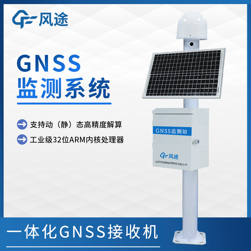
The GNSS displacement monitoring station is a device that utilizes Global Navigation Satellite System (GNSS) technology and is specifically designed for surface displacement monitoring. It receives satellite signals and accurately monitors the slightest changes in the target position. It is widely used in fields such as geological disaster prevention, building safety monitoring, and traffic road safety.
This equipment mainly consists of a GNSS antenna, a solar panel, a main control chassis, and a mounting bracket. It has the advantages of high precision, low power consumption, and convenient installation. The GNSS displacement monitoring station can upload monitoring data in real-time to the monitoring platform via 4G or Ethernet, achieving data sharing and remote monitoring, and providing crucial support for disaster warning and engineering safety.
The price range of the GNSS displacement monitoring station is relatively wide. Generally, the price of a more basic model is around 3,000 yuan - 5,000 yuan. The medium-configured ones usually cost between 6,000 yuan - 10,000 yuan. And for high-end products with more powerful functions, higher precision, and more complete configurations, the price may be around 10,000 yuan - 20,000 yuan. The price differences mainly stem from factors such as the equipment's precision, functions, configurations, and brand. Products with high precision, complex data processing capabilities, and better protection performance are relatively more expensive.
In weather monitoring and many industrial fields, accurate measurement of wind speed holds a crucial position. In addition to the common cup anemometers and ultrasonic anemometers, although duct wind speed transmitters are not often well-known to the general public, they have extensive applications....
Utilizing Differential RTK technology, this geological hazard monitoring equipment achieves millimeter-level displacement monitoring for dams, bridges, and landslide bodies. Its built-in sensors are capable of operating around the clock in complex environments, while its data acquisition and e...
anemometer measures is a measuring device that measures the wind speed. It is a commonly used instrument in weather stations....
Shipborne automatic weather station is a kind of meteorological observation system using ship as a working platform, which is capable of real-time observation of elements of marine meteorology such as temperature, air pressure, humidity, wind speed, wind direction, rainfall and visibility. In the fi...


 Skype
Skype
 whatsapp
 mail
mail