Shandong Fengtu IOT Technology Co., Ltd
Sales Manager:Ms. Emily Wang
Cel,Whatsapp,Wechat:+86 15898932201
Email:info@fengtutec.com
Add:No. 155 Optoelectronic Industry Accelerator, Gaoxin District, Weifang, Shandong, China


Sales Manager:Ms. Emily Wang
Cel,Whatsapp,Wechat:+86 15898932201
Email:info@fengtutec.com
Add:No. 155 Optoelectronic Industry Accelerator, Gaoxin District, Weifang, Shandong, China
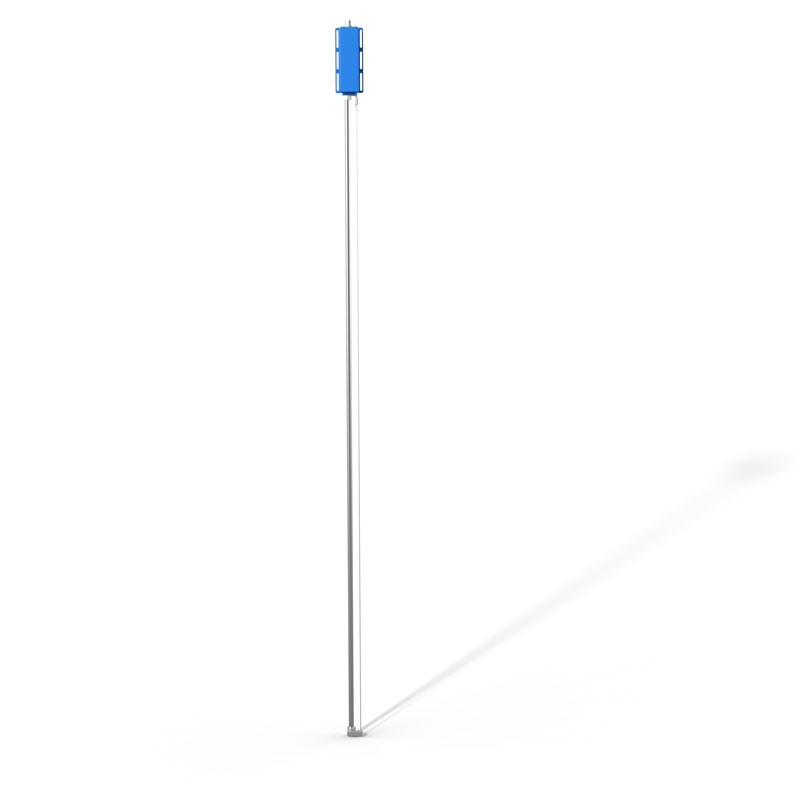
Model:FT-LG100
Brand:fengtu
1、Wave gauge system Product Introduction
Wave gauge system is used for testing or monitoring of laboratory or offshore buoys, ships, etc, the monitoring items include free fluid wave, water level height, etc.Wave gauge system is a high-performance hydrological monitoring device integrating a low-power microprocessor, a 24-bit high-precision AD converter, and a capacitive wave height sensor.
Its integrated structure enables convenient installation and excellent stability. Simultaneously, the device employs RS485 long-distance communication technology, ensuring anti-interference capability and reliable data transmission over long distances.
This instrument boasts stable performance and is specifically designed for the accurate measurement of wave parameters and water level in free fluids. It not only features extremely low power consumption but also excellent linearity, high precision, fast response, no mechanical contact, and high reliability.
It is an ideal choice for long-term reliable monitoring in marine, port, reservoir, and lake environments.
2、Wave gauge system Technical Specifications
Measuring Range: 0-1000mm
Resolution: 0.1mm
Measuring Accuracy: ≤0.1%F.S
Sampling Frequency: >100Hz
Operating Voltage: DC12V
Rated Power Consumption: <0.5W
Output Signal: RS485-MODBUS Protocol
Operating Temperature: 0℃~+60℃
Storage Temperature: -40℃~+70℃
Protection Rating: IP67
Housing Material: 304 Stainless Steel
Cable Length: 5m
Installation Method: Vertical Fixed Installation
The 3D Ultrasonic Anemometer is a high-precision gas flow velocity measurement device, which is widely used in meteorological observation, air quality monitoring, meteorological disaster early warning, built environment monitoring, and wind energy resource assessment. The device calculates wind spee...
This is a full-color screen, highly intelligent negative oxygen ion monitoring station developed by Windway Technology on the basis of the old model, based on previous R&D experience! Interested, you can contact the customer for consultation! Next, let's see what features the device has!FT-F...
rain gauge meaning is an instrument that measures precipitation and is used to determine the depth of precipitation occurring over a unit area....
Meteorological monitors:A weather monitor is usually an automated device used to measure and record environmental weather conditions including temperature, humidity, air pressure, wind speed, wind direction, rainfall, solar radiation and more. They typically consist of multiple sensors, data loggers...


 Get a Free Quote
 Skype
Skype
 whatsapp
 mail
mail