Shandong Fengtu IOT Technology Co., Ltd
Sales Manager:Ms. Emily Wang
Cel,Whatsapp,Wechat:+86 15898932201
Email:info@fengtutec.com
Add:No. 155 Optoelectronic Industry Accelerator, Gaoxin District, Weifang, Shandong, China


Sales Manager:Ms. Emily Wang
Cel,Whatsapp,Wechat:+86 15898932201
Email:info@fengtutec.com
Add:No. 155 Optoelectronic Industry Accelerator, Gaoxin District, Weifang, Shandong, China
Model:FT-GQX8
Brand:fengtu
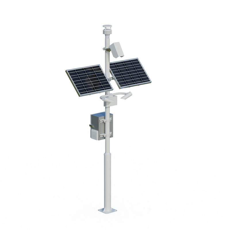
1.Road Weather Information System Product Introduction
Road Weather Information System monitors the road environment and provides visibility, wind speed, wind direction, temperature, humidity, atmospheric pressure, rainfall and other data.Road Weather Information System uses integrated applications of various meteorological sensors from structure to system composition using integrated acquisition and control technology, computer software technology, communication technology and other technologies.It can continuously obtain meteorological information along the traffic route, can conduct real-time monitoring of meteorological elements such as visibility, wind speed, wind direction, temperature, humidity, atmospheric pressure, rainfall, road conditions, etc., and summarize various data through remote transmission and promptly transmit it to the transportation department, providing first-hand information for transportation related departments to provide meteorological guarantee services along the traffic route.Based on this, timely meteorological information services can be provided for highway safety authorities and people's travel.
Road Weather Information System system composition: visibility sensor, remote sensing road condition sensor, weather sensor, collector, pole bracket, power supply system, cloud platform
2.Road Weather Information System product features
1.Visibility meter: consists of main components such as light emitter, light receiver and microprocessor controller.The transmitter emits infrared pulsed light, and the receiver simultaneously detects the pulse light intensity of forward scattered aerosol particles in the atmosphere.All measurement information is collected by the microprocessor controller and converted into meteorological optical range through a special mathematical model algorithm.
2.Integrated sensor with six elements: temperature, humidity, wind speed, wind direction, atmospheric pressure, and piezoelectric rainfall
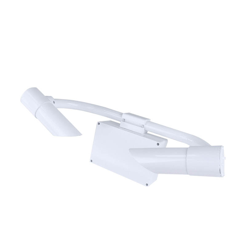
3.Wind speed and wind direction sensor: The cover of the probe is hidden to avoid interference from rain and snow accumulation, and to avoid natural wind obscurity.The principle is to transmit a continuous frequency conversion ultrasonic signal, and to detect the wind speed and direction by measuring the relative phase.
4.Piezoelectric rainfall: This piezoelectric rainfall sensor uses PVDF piezoelectric film as a rain sensing device, and uses an embedded AI neural network to distinguish raindrop signals to avoid mistriggering caused by interference such as gravel, dust, and vibration.
5.Standard GPRS wireless transmission
6.Free choice of two power supply methods: solar power supply and mains power supply
3.Road Weather Information System Technical Parameters
1.Visibility: Principle of measurement aerosol prescattering, 5m-10km (≤2km ±2%2km~10km ±5%>10km ±10%) resolution 1m
2.Wind speed: measurement principle ultrasonic wave, 0~60m/s (±0.1m/s) resolution 0.01m/s
3.Wind direction: measurement principle ultrasonic wave, 0~360° (±2°); resolution: 1°
4.Air temperature: measurement principle diode junction voltage method, -40-60℃ (±0.3℃), resolution 0.01℃
5.Air humidity: measurement principle capacitive type, 0-100%RH (±3%RH), resolution: 0.1%RH
6.Atmospheric pressure: measurement principle piezoresistive type, 300-1100hpa (±0.25%), resolution 0.1hpa
7.Piezoelectric rainfall: measurement principle piezoelectric, 0-4mm/min (≤±4%), resolution 0.01mm
8.Road surface condition: measurement principle infrared remote sensing measurement
Model LM1 detection distance and detection area diameter 2-8 meters; 23cm installation angle for horizontal line 30-80 degrees Power supply and power consumption DC12-24V; 0.6W Operating temperature and humidity temperature: -40ºC to +60ºC; Humidity: 0 to 95% Water accumulation thickness 0-10mm Ice cover thickness 0-2mm Snow accumulation thickness 0-2mm Slippery degree 0.01 (slippery) -0.82 (strong friction) Pavement status report dry, damp, wet, snow, ice, ice and water mixed road weather phenomenon (optional) Pavement temperature: -40ºC to +60ºC Weather phenomenon: rain; snow; heavy fog pavement material concrete, asphalt pavement communication RS485, RS232
9.Manufacturers have ISO quality management system, environmental management system and occupational health management system certification
10.The manufacturer has a computer software registration certificate
11.The manufacturer is a 3A credit enterprise
4.Introduction to Road Weather Information System Cloud Platform
1.CS architecture software platform, supports direct observation of mobile phones and PC browsers without additional software installation.
2.Support multiple accounts and multiple devices to log in
3.Support real-time data display and historical data display dashboard
4.Cloud server and cloud data storage are stable and reliable, easy to scale, and load balancing.
5.Support SMS alarm and threshold settings
6.Support map display and viewing device information.
7.Support data curve analysis
8.Support data export table form
9.Supports data forwarding, HJ-212 protocol, TCP forwarding, http protocol, etc.
10.Support data post-processing function
11.Support external running of javascript scripts
A visibility detector is a device used to measure atmospheric visibility. It helps meteorologists, traffic controllers, pilots, and others to understand the current visibility conditions in the atmosphere so that they can make decisions accordingly.In meteorology, visibility is a key concept that de...
IOT weather station equipment manufacturers recommended, wind way technology is a collection of R & D design, manufacturing and sales in one of the high-tech enterprises, the company was founded since always adhering to the "customer first" business philosophy, adhere to the integrity...
Wireless level monitoring in wastewater treatment plants, is radar level meter feasible?To treat wastewater, it needs to go through a variety of processes, and this will involve the measurement of liquid level, flow, pressure, temperature, ph, dissolved oxygen, turbidity and other parameters, among...
Depth Sounder is an electronic instrument that measures water depth using the principle of sound wave propagation in water. This device calculates the time interval between the transmission and reception of ultrasonic waves reflected from the seabed, and automatically converts this time interval into a water depth value based on the known speed of sound. Its core component is an underwater transducer, and it features portability and adjustable accuracy. It is widely used in professional fields such as hydrological surveys of rivers, lakes, and oceans, navigation, and underwater engineering measurements....


 Get a Free Quote
 Skype
Skype
 whatsapp
 mail
mail