Shandong Fengtu IOT Technology Co., Ltd
Sales Manager:Ms. Emily Wang
Cel,Whatsapp,Wechat:+86 15898932201
Email:info@fengtutec.com
Add:No. 155 Optoelectronic Industry Accelerator, Gaoxin District, Weifang, Shandong, China


Sales Manager:Ms. Emily Wang
Cel,Whatsapp,Wechat:+86 15898932201
Email:info@fengtutec.com
Add:No. 155 Optoelectronic Industry Accelerator, Gaoxin District, Weifang, Shandong, China

Model:FT-CS150+
Brand:fengtu
1、Boat Depth Finder Product Introduction
Boat Depth Finder is a water depth measurement device that is accurate, efficient and portable, and is used in oceans, lakes, rivers and other waters.Boat Depth Finder is a portable depth sounder for measuring water bodies such as reservoirs, lakes, rivers, and shallow seas. To measure depth, an ultrasonic transducer is placed at a predetermined position below the water surface. Using the fixed velocity of ultrasound in water (V) and the time between transmission and reception (T), the instrument automatically calculates the water depth (H). This convenient and versatile handheld ultrasonic distance meter was developed by our company, drawing on years of production experience and the strengths of various similar products. The ultrasonic transceiver and converter circuit utilizes a dedicated large-scale integrated circuit (LSI) with a 99% component placement rate. The LCD displays the depth measurement results, ensuring long-term reliability while minimizing power consumption. The instrument offers precise measurements, low power consumption, high reliability, ease of use, simple operation, accurate measurement speed, and portability. It can measure depth in both still and swift water, with water velocities ≤ 5 m/s. It is an ideal depth measurement instrument for hydrological surveys, hydropower plant reservoirs, lake and river surveys, and environmental water monitoring.
2、Boat Depth Finder Technical Features
For external (inboard) installation on medium and small boats, with a 10-meter cable.
Simultaneously displays water depth, water temperature, latitude and longitude coordinates, travel speed, time, date, battery status, and Bluetooth connection status.
Self-stabilizing measurement technology and fast tracking technology provide real-time measurement results.
Built-in watchdog circuit ensures reliable and stable operation over long periods of time.
High-precision clock with an annual error of 3 PPM.
Storage utilizes a 16MB FLASH analog USB drive, allowing direct data access from a computer via a USB cable.
Automatically stores data in CSV format using the FAT32 file system.
High-brightness display for clearer field measurement data.
Beidou GPS dual-mode positioning displays real-time latitude and longitude, as well as ground speed.
Printer-free data printing via Bluetooth connection.
RS485 data output allows direct data access from a host computer, extending communication range.
Automatically adjusts echo sampling threshold, transmit power, and amplifier gain.
3、Boat Depth Finder Technical Parameters
| Measurement principle | Ultrasonic ranging method |
| Range of measurement | 0-150 meters |
| Blind spot | ≤0.5 meters |
| Power | Transmission power 32 levels, automatic gain adjustment |
| Minimum display resolution | 0.1mm |
| Precision | ±0.5%×full scale |
| Display | Chinese LCD full color screen display |
| Working frequency | 200~2000KHz automatic adjustment |
| On-site set-up: | Complete by pressing the main key |
| Calibration: | Factory calibration, can be calibrated on site |
| Output, storage | USB reads data, board flash automatically generates an EXCEL file for measurement data, maximum storage quantity 10000. |
| Working voltage: | Built-in battery, external charger |
| Keyboard: | Number keys |
| Material: | Host: ABS engineering plastic |
| Sensor: ABS engineering plastic | |
| Measuring rod: stainless steel, 2 pieces | |
| Weight: | Host: 330g |
| Sensor: 650~750g | |
| Sensor cable: | Diameter 5-10mm x 10m |
| Sensor counterweight pipe: | Length 53cm |
| Temperature measurement range: | -45℃~85℃ |
| Working temperature: | ≤80%RH no dew |
| Storage temperature: | ≤80%RH no dew-40℃~70℃ |
Why do we need automatic weather stations when we have weather forecasts?...
transmission line micrometeorological monitoring system.The guardian of micrometeorology.Under the seemingly simple appearance.It hides the magic of science and technology.It's powered by solar panels.No need to take care of it.It monitors the weather around the clock.Wind speed, wind direction,...
GNSS receiver price This product, which utilizes differential RTK technology to achieve millimeter-level displacement monitoring, is priced at 6900 RMB. It boasts high accuracy and strong stability, making it suitable for safety monitoring of engineering projects such as dams, bridges, and lan...
In the daily operation of wastewater treatment plants, ammonia nitrogen detection is essential. Ammonia nitrogen refers to the nitrogen present in water in the form of free ammonia (NH3) and ammonium ions (NH4+). Excessively high ammonia nitrogen levels can deplete dissolved oxygen in water bodies,...


 Get a Free Quote
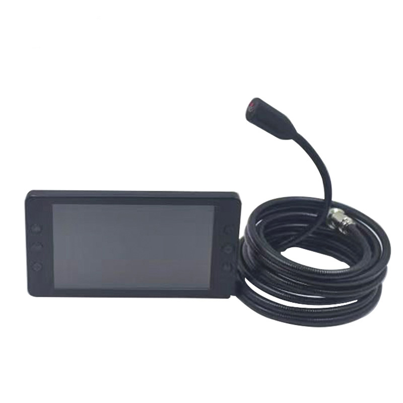
 Skype
Skype
 whatsapp
 mail
mail