Shandong Fengtu IOT Technology Co., Ltd
Sales Manager:Ms. Emily Wang
Cel,Whatsapp,Wechat:+86 15898932201
Email:info@fengtutec.com
Add:No. 155 Optoelectronic Industry Accelerator, Gaoxin District, Weifang, Shandong, China


Sales Manager:Ms. Emily Wang
Cel,Whatsapp,Wechat:+86 15898932201
Email:info@fengtutec.com
Add:No. 155 Optoelectronic Industry Accelerator, Gaoxin District, Weifang, Shandong, China
time:2022-11-21 08:45:21 source:Weather Station viewed:929 time
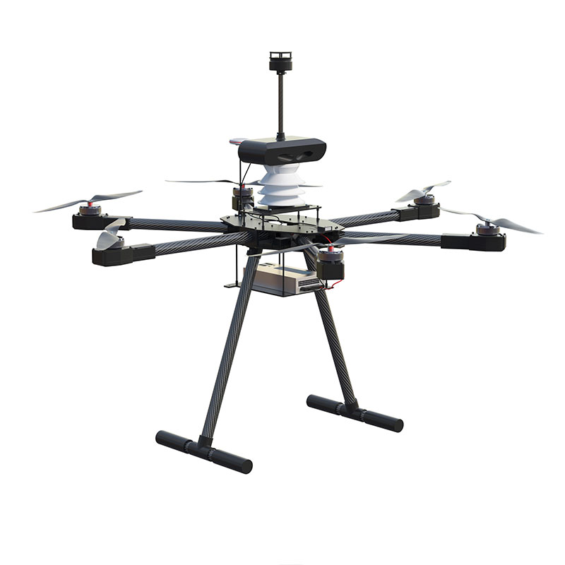
Automatic radar water level rainfall monitoring system has the advantages of simple structure and low cost, which is widely used in water conservancy projects. At present, the number of automatic radar water level rainfall stations is increasing and the degree of automation is improving, and there has been a great development in its function and technology.
Windway Technology is a manufacturer of automatic radar water level rainfall monitoring system, which adopts microwave radar technology and combines the experience accumulated over the years to develop a series of products to realize the real-time detection of various water conditions. Since this product can complete the collection and display of water level, flow rate and flow velocity information without manual operation and guarding compared with traditional manual rainfall measurement, it is generally welcomed in the domestic market. This is an advanced and reliable, easy to use and easy to manage intelligent water monitoring equipment for the majority of water conservancy workers to provide a good solution.
Hydrological information is one of the most important components of water resources, including river water quantity, water quality and hydrometeorological data, and hydrological monitoring equipment can be based on these data for unified analysis, the results in the form of text or charts to show, so that users can understand the situation and make appropriate decisions in a timely manner, in order to achieve timely warning and control the reservoir release or water transfer purposes.
Automatic radar water level and rainfall monitoring system is to use intelligent sensors to obtain water flow change parameters, wind direction and speed, water level condition, rainfall intensity and other index information, through computer processing to form a complete comprehensive information chart of water conditions. It can also send flood forecast information and other kinds of disaster warning tips to users. In the actual application process, the automatic radar water level rainfall monitoring system is generally composed of monitoring station, communication platform and so on. Among them, the monitoring station is the core part of the whole system operation, which not only undertakes the task of collecting, storing and organizing the massive hydrological basic data signal resources, but also responsible for receiving, storing and transmitting the data transmission requests from various parties. In addition, between each monitoring point, a wireless communication network network has to be established, so as to ensure smooth communication.

Water level monitoring instrument is specifically designed for precise distance measurement, utilizing the FMCW (Frequency Modulated Continuous Wave) mode. It features non-contact installation, a compact structure, low power consumption, and strong anti-interference capabilities, making...
weather measuring equipment used for weather and monitoring weather data over a period of time, measuring meteorological parameters such as temperature, pressure, rainfall, wind direction, wind speed, and humidity....
Weather Station Data Logger is an integrated monitoring device specifically designed for hazardous environments such as chemical plants and oil depots. It features a corrosion-resistant, explosion-proof, waterproof, shockproof, and dustproof design. It can monitor five elements: wind speed and direction, temperature, humidity, and atmospheric pressure. With miniaturization and explosion-proof capabilities as its core, it is suitable for high-risk industrial scenarios with limited space....
Within the scope of meteorology, wind speed and direction, as key meteorological elements, are of great significance to human production activities. Most traditional wind speed measurement methods and instruments can only measure two-dimensional wind speed. However, wind speed is actually a three-di...


 Skype
Skype
 whatsapp
 mail
mail