Shandong Fengtu IOT Technology Co., Ltd
Sales Manager:Ms. Emily Wang
Cel,Whatsapp,Wechat:+86 15898932201
Email:info@fengtutec.com
Add:No. 155 Optoelectronic Industry Accelerator, Gaoxin District, Weifang, Shandong, China


Sales Manager:Ms. Emily Wang
Cel,Whatsapp,Wechat:+86 15898932201
Email:info@fengtutec.com
Add:No. 155 Optoelectronic Industry Accelerator, Gaoxin District, Weifang, Shandong, China
time:2025-01-08 10:12:03 source:Weather Station viewed:711 time
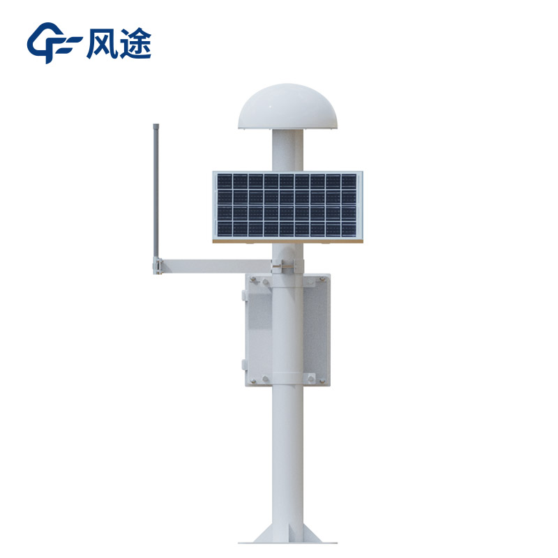
The GNSS monitoring station, based on the Global Navigation Satellite System, is a high-precision displacement monitoring device. It consists of a GNSS antenna, a solar panel, a main control chassis and a mounting bracket. It features high precision, low power consumption, high cost-performance ratio and convenient installation. The data is transmitted to the environmental monitoring platform via 4G or Ethernet. Powered by solar energy, it is not restricted by geographical terrain and is used for monitoring surface displacement and building deformation, such as landslide, slope displacement, bridge deformation, reservoir dam and mine geological disaster monitoring.
However, in some areas, although the stations are installed and monitored all day long, it is still difficult for the staff to detect abnormalities in advance. This is mostly due to incorrect installation or usage methods that affect the measurement results. The reference station should be installed far away from places with displacement changes. If both the measurement station and the reference station are installed in such places, measurement errors will occur. Among the seven errors in GNSS positioning, namely orbit, satellite, ionosphere, troposphere, multipath, receiver clock difference and receiver noise, the ionosphere error has the greatest impact.
When selecting the installation location of the GNSS monitoring station, the measurement station should be arranged in the disaster body area with large deformation, while the reference station should be set in the stable area outside the disaster body, far away from places where displacement changes may occur. The installation of the solar panel is very important. There should be no obstructions above it, otherwise the hot spot effect and the barrel effect of current may occur. The optimal installation angle of the solar panel should be within 20 degrees towards the southwest direction, and the tilt angle should be between 30 and 45 degrees. The specific angle can be adjusted according to the local latitude.
The GNSS monitoring station needs to be installed in an open-air environment to ensure good satellite signal reception conditions. The monitoring location should be selected in an empty place to ensure that there are no large-area obstructions above the positive -15 degree elevation cutoff angle.
It is also necessary to pay attention to the following points: avoid installing in low-lying areas that are prone to water accumulation, stay away from electromagnetic interference that may be generated by underground pipelines, and avoid hidden areas with poor signal. This can ensure the accuracy of the monitoring data and provide a reliable basis for safety warnings and decision-making.
water quality detector uses chemical, physical or biological reactions to measure conductivity, dissolved oxygen, pH, COD and other parameters, suitable for monitoring natural water, surface water or groundwater quality....
The history of human measurement of wind is extensive, evolving from ancient wind vanes and anemometers to modern high-tech equipment. Initially, people measured wind by observing wind vanes and anemometers. During the Renaissance, scientists invented more precise anemometers. In the 18th century, t...
Micrometeorology refers to small-scale climatic features in the near-surface atmosphere and soil that are triggered by specific configurations of the subsurface. These features are usually reflected in individual meteorological values or individual weather phenomena (e.g. wind, rain, fog, frost, etc...
In the field of soil and water conservation research, runoff plots are important observation units. They refer to enclosed observation areas with a certain area and boundaries demarcated on sloping or flat land for studying the laws of soil erosion. These areas, equipped with enclosing ridges, catch...


 Skype
Skype
 whatsapp
 mail
mail