Shandong Fengtu IOT Technology Co., Ltd
Sales Manager:Ms. Emily Wang
Cel,Whatsapp,Wechat:+86 15898932201
Email:info@fengtutec.com
Add:No. 155 Optoelectronic Industry Accelerator, Gaoxin District, Weifang, Shandong, China


Sales Manager:Ms. Emily Wang
Cel,Whatsapp,Wechat:+86 15898932201
Email:info@fengtutec.com
Add:No. 155 Optoelectronic Industry Accelerator, Gaoxin District, Weifang, Shandong, China
time:2024-12-16 10:03:14 source:Weather Station viewed:809 time
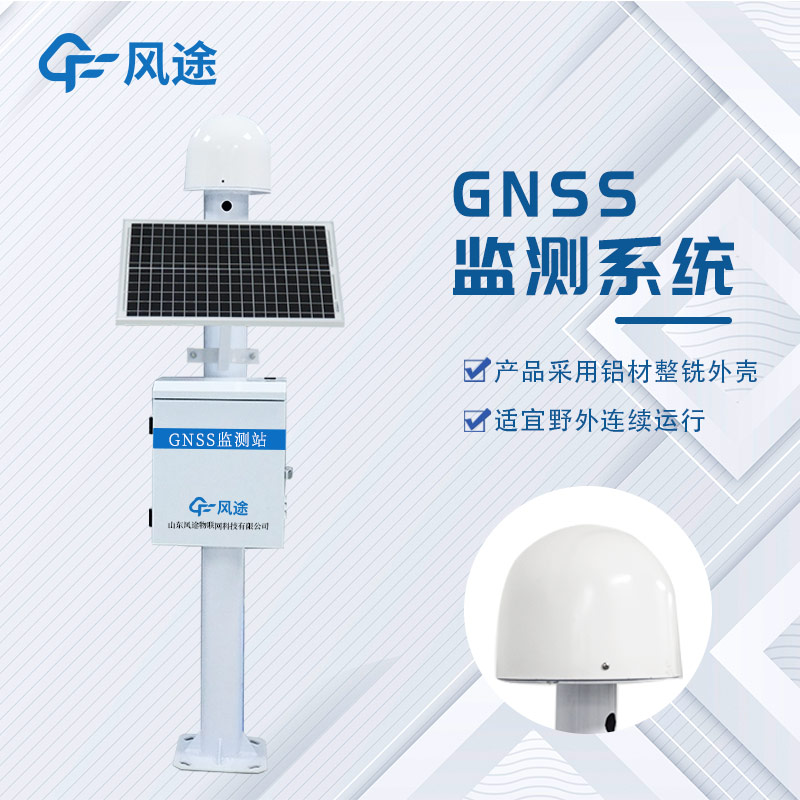
The GNSS monitoring station for mine slopes is a crucial technical means to ensure the safe production of mines. This system mainly consists of a data acquisition terminal, a network transmission terminal, and a management center terminal.
The various sensors at the data acquisition terminal, such as GNSS receivers, inclinometers, piezometers, and rain gauges, collect data on the displacement, inclination, groundwater level, and rainfall of the slope in real time and convert them into electrical or digital signals. The network transmission terminal uses industrial wireless routers, communication base stations, and other equipment to transmit the data quickly and stably to the management center terminal. The servers, data processing software, and databases at the management center terminal store, manage, and analyze the data, and evaluate the slope stability through professional algorithms.
Its monitoring content covers displacement monitoring, stress monitoring, and environmental monitoring, providing a basis for comprehensively understanding the slope conditions. The key technologies include high-precision sensor technology, satellite positioning technology, data communication technology, and data analysis and processing technology to ensure the stable operation of the system and the accurate analysis of data.
The system has functions such as real-time monitoring and early warning, data analysis and evaluation, remote monitoring and management, and historical data query and traceability. It can detect potential slope hazards in a timely manner, provide scientific decision-making support for mine safety management, effectively reduce the risk of mine slope accidents, and is an essential guarantee for the safe production of mines.
what is automatic weather station, automatic weather station is an automated version of a traditional weather station. It is a modern device capable of measuring, storing and uploading meteorological data to measure a variety of meteorological parameters....
Automatic water quality monitoring is of great significance for freshwater resource management. Its monitoring parameters include physical parameters (such as temperature, pH value, turbidity) and chemical parameters (such as dissolved oxygen, residual chlorine). Temperature reflects the hydrotherma...
Small agricultural weather station is a new modern monitoring system that uses modern information technology and network means to assist agricultural producers to carry out yield prediction and analysis of agricultural products, guide growers to reasonably determine the sowing time, timely harvest,...
With the socio-economic development and the improvement of people's living standard, people put forward higher requirements for weather forecasting services, and the traditional manual observation can no longer meet this demand, therefore, it is necessary to accelerate the pace of construction o...


 Skype
Skype
 whatsapp
 mail
mail