Shandong Fengtu IOT Technology Co., Ltd
Sales Manager:Ms. Emily Wang
Cel,Whatsapp,Wechat:+86 15898932201
Email:info@fengtutec.com
Add:No. 155 Optoelectronic Industry Accelerator, Gaoxin District, Weifang, Shandong, China


Sales Manager:Ms. Emily Wang
Cel,Whatsapp,Wechat:+86 15898932201
Email:info@fengtutec.com
Add:No. 155 Optoelectronic Industry Accelerator, Gaoxin District, Weifang, Shandong, China
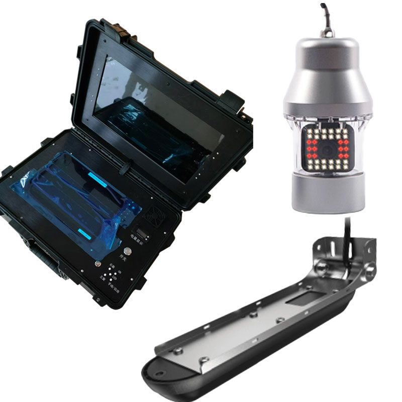
Model:FT-QSN3
Brand:fengtu
Underwater rescue sonar detector product introduction
Underwater rescue sonar detector can scan underwater geomorphology, suitable for emergency rescue, public security, maritime, coast guard, port and other units to search for underwater objects.The multi-functional underwater sonar search and rescue system technology is constantly exploring.With the help of extremely clear imaging technology, it provides the scanning views of riverbeds and waters, three-dimensional views and detection of underwater life for the rescuers, which can provide more intuitive understanding of the underwater structure.It improves the efficiency of underwater operations and is one of the important equipment that can be relied on underwater salvage and rescue.
1.Screen type: 9-inch IPS screen, resolution ≥1900*1080, brightness ≥1200 nits.
2.Screen function: Chinese operating system, can turn on four-segment/six-segment screens, view four/six screens at the same time, and can be independently controlled, or a combination interface can be set at will, which can display positioning, water temperature, time, and range.
3.Pressure-resistant water depth: ≥300m.
4.Waterproof level: ≥IP68.
5.Shortcut key function: It has 5 custom editable shortcut keys.
6.Visual angle: vertical viewing angle 160°, 80° up/down, horizontal viewing angle 160°, 80° left/right.
7.Exploration and measurement range: Sweep under the structure ≥90m, side sweep in the structure ≥180m, maximum range depth ≥300m.
8.Support functions: automatic steering, Bluetooth connection, radar compatibility 3G, 4G, HALO24 radar antenna, GPS, WAAS/EGNOS, global simple navigation chart, automatic ship recognition, built-in CHIRP1 and CHIRP2 dual-channel sonar.
9.Sonar operating frequency: 50KHZ/83KHZ/200KHZ/455KHZ/800KHZ/1200KHZ, CHIRP frequency is available.
10.Recording function: Sonar, structure scanning has recording function to playback and analyze.
11.Working voltage: 12V.
12.Power consumption: 33.12W.
13.Sonar power: 600W.
14.Use ambient temperature: -15℃~+55℃.
15.Device configuration: NMEA0183 data output/input RS422, supports baud rate 4800, 19200, 38400, 2 Ethernet interfaces, 1 NMEA2000 data interface, video input interface, 2 micro SD data card slots, maximum support 32G .
16.Waypoint and track storage quantity: 3,000 waypoint storage quantity, 100 track storage quantity, 100 track storage quantity, 100 (up to 10,000 points per track), supports automatic ship identification system, and can support audio amplifier connect.
17.Sonar alarm: shallow water alarm, GPS alarm function.
18.Power supply configuration: The power supply box has two power supply modes, namely built-in battery power and external AC power supply.The power supply box can display the battery power, can quickly plug and unplug the battery interface to charge, the battery life is ≥12 hours, and the external AC power supply is Unlimited battery life can be achieved.
19.Remove the bracket and handheld probe: The main unit and sonar probe should have an mountable and removable bracket, which can be quickly installed and used on the assault boat/rubber boat, and has the function of adjusting the depth and shallowness of the sonar probe.
20.Underwater view probe
Probe diameter: ≤70mm.
Height: ≤162mm.
Waterproof grade: ≥IP68.
Viewing angle: 120°.
Rotation angle: It can rotate left and right by 360°.
Cable: 50 meters standard with a diameter of 5MM, which can be used for underwater and deep well detection.
Working water depth: 50 meters.
Use temperature: -20--60 degrees.
Storage temperature: -30--80 degrees.
Adjustment mode: manual/automatic.
Lighting function: ≥36 high-bright night vision lights, 24 white lights, 12 infrared lights, and have white lights and infrared switching functions.
21.Underwater 3D probe, with underwater three-dimensional stereo imaging capabilities
Side scan/down scan imaging: 455/800KHZ.
Probe power: 500w RMS, working temperature range -28~75 degrees Celsius, waterproof level ipx7.
Power supply: 12/24V dual voltage, working voltage range of 9V to 32V DC.
Standard cable: 6 meters.
Support software upgrade and update.
22.Underwater real-time dynamic sonar probe, with real-time dynamic imaging capabilities
Scan range: 135 degrees angle, you can switch modes such as down sweep, front sweep, front sweep and other modes.
Sonar frequency range: 550KHZ~1100KHZ, with traditional sonar functions.
Maximum range: ≥150 meters, effective range ≥60 meters.
Waterproof grade: ip67.
Storage temperature range: -30~70 degrees Celsius, and the water temperature range of the probe is 0~35 degrees Celsius.
Supply voltage: dual voltage of 12/24V, operating voltage range of 10.8V to 31.2V DC, maximum current of 1.5A.
Standard cable: 7.6 meters.
Support software upgrade and update.
The photoelectric rain gauge is a rain detector based on the optical principle, which utilizes changes in light signals to measure rainfall. It is a relatively new rainfall detection technology with the advantages of high accuracy, fast response and reliability.The working principle of the optical r...
Mining operations are like a double-edged sword: while fueling economic growth, they leave behind environmental challenges, with slope instability and soil erosion being the most pressing. Mountain landslides are no trivial matter—accidents such as equipment burial and worker entrapment occur frequ...
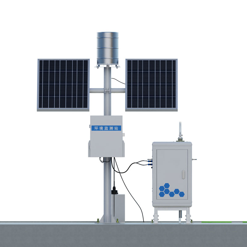
The GNSS displacement monitoring station is a device that utilizes Global Navigation Satellite System (GNSS) technology and is specifically designed for surface displacement monitoring. It receives satellite signals and accurately monitors the slightest changes in the target position. It is widely u...
meteorological station A monitoring system established to acquire meteorological data, used on land or at sea, equipped with instruments and equipment for measuring atmospheric conditions....


 Get a Free Quote
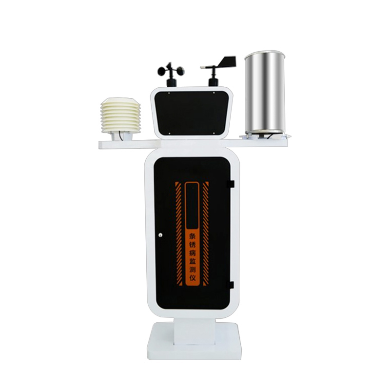
 Skype
Skype
 whatsapp
 mail
mail