Shandong Fengtu IOT Technology Co., Ltd
Sales Manager:Ms. Emily Wang
Cel,Whatsapp,Wechat:+86 15898932201
Email:info@fengtutec.com
Add:No. 155 Optoelectronic Industry Accelerator, Gaoxin District, Weifang, Shandong, China


Sales Manager:Ms. Emily Wang
Cel,Whatsapp,Wechat:+86 15898932201
Email:info@fengtutec.com
Add:No. 155 Optoelectronic Industry Accelerator, Gaoxin District, Weifang, Shandong, China
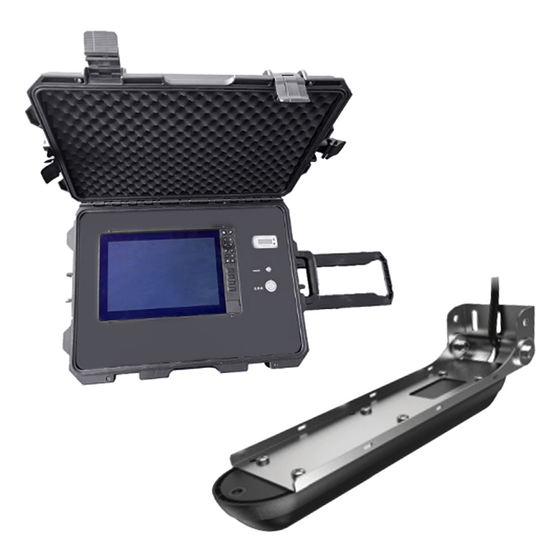
Model:FT-CSN1
Brand:fengtu
Underwater Sonar Life Rescue Detector Product Introduction
Underwater Sonar Life Rescue Detector displays underwater terrain and sunken objects through a sonar imaging system to provide real-time underwater life information for emergency responders.The multi-functional underwater sonar search and rescue system technology is constantly exploring.With the help of extremely clear imaging technology, it provides the scanning views of riverbeds and waters, three-dimensional views and detection of underwater life for the rescuers, which can provide more intuitive understanding of the underwater structure.It improves the efficiency of underwater operations and is one of the important equipment that can be relied on underwater salvage and rescue.
1.Screen type: 7-inch IPS screen, resolution ≥1200*900, brightness ≥1200 nits.
2.Screen function: Chinese operating system, can turn on four-segment/six-segment screens, view four/six screens at the same time, and can be independently controlled, or a combination interface can be set at will, which can display positioning, water temperature, time, and range.
3.Pressure-resistant water depth: ≥300m.
4.Waterproof level: ≥IP68.
5.Shortcut key function: It has 5 custom editable shortcut keys.
6.Visual angle: vertical viewing angle 160°, 80° up/down, horizontal viewing angle 160°, 80° left/right.
7.Exploration and measurement range: Sweep under the structure ≥90m, side sweep in the structure ≥180m, maximum range depth ≥300m.
8.Support functions: automatic steering, Bluetooth connection, radar compatibility 3G, 4G, HALO24 radar antenna, GPS, WAAS/EGNOS, global simple navigation chart, automatic ship recognition, built-in CHIRP1 and CHIRP2 dual-channel sonar.
9.Sonar operating frequency: 50KHZ/83KHZ/200KHZ/455KHZ/800KHZ/1200KHZ, CHIRP frequency is available.
10.Recording function: Sonar, structure scanning has recording function to playback and analyze.
11.Working voltage: 12V.
12.Power consumption: 33.12W.
13.Sonar power: 600W.
14.Use ambient temperature: -15℃~+55℃.
15.Device configuration: NMEA0183 data output/input RS422, supports baud rate 4800, 19200, 38400, 2 Ethernet interfaces, 1 NMEA2000 data interface, video input interface, 2 micro SD data card slots, maximum support 32G .
16.Waypoint and track storage quantity: 3,000 waypoint storage quantity, 100 track storage quantity, 100 track storage quantity, 100 (up to 10,000 points per track), supports automatic ship identification system, and can support audio amplifier connect.
17.Sonar alarm: shallow water alarm, GPS alarm function.
18.Power supply configuration: The power supply box has two power supply modes, namely the built-in battery power and the external AC power supply.The power supply box can display the battery power, can quickly plug and unplug the battery interface to charge, the battery life is ≥14 hours, and the external AC power supply is Unlimited battery life can be achieved.
19.Remove the bracket and handheld probe: The main unit and sonar probe should have an mountable and removable bracket, which can be quickly installed and used on the assault boat/rubber boat, and has the function of adjusting the depth and shallowness of the sonar probe.
Smart streetlights need all-in-one environmental sensorsWhat are smart streetlights?Intelligent street lights use advanced technology to achieve remote centralised control, adjusting brightness according to traffic flow, remote control of lighting, automatic alarm, anti-theft and remote meter readin...
Atmospheric transmittance refers to the ratio of the luminous flux that passes through the atmosphere to the incident luminous flux when light propagates in the atmosphere. When the atmospheric transmittance is high, it means that more light can successfully propagate in the atmosphere. In this case...
Industrial Weather Station is specifically engineered for chemical plants and oil depots, featuring an integrated design for data acquisition and communication. Certified as explosion-proof, its "Five-Protection" design makes it ideally suited for high-risk locations where flammable...
The five element weather monitor is used to monitor the five elements of weather, namely temperature, humidity, air pressure, wind speed and wind direction. It usually consists of a number of sensors and data loggers that can monitor and record these elements in real time. The five element weather m...


 Get a Free Quote
 Skype
Skype
 whatsapp
 mail
mail