Shandong Fengtu IOT Technology Co., Ltd
Sales Manager:Ms. Emily Wang
Cel,Whatsapp,Wechat:+86 15898932201
Email:info@fengtutec.com
Add:No. 155 Optoelectronic Industry Accelerator, Gaoxin District, Weifang, Shandong, China


Sales Manager:Ms. Emily Wang
Cel,Whatsapp,Wechat:+86 15898932201
Email:info@fengtutec.com
Add:No. 155 Optoelectronic Industry Accelerator, Gaoxin District, Weifang, Shandong, China
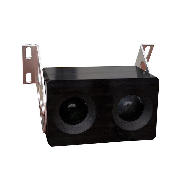
Model:FT-WJN4
Brand:fengtu
1.Uav visibility meter product features
Uav visibility meter is a microprocessors controlled atmospheric visibility monitoring instrument that uses the forward scattering principle of light.
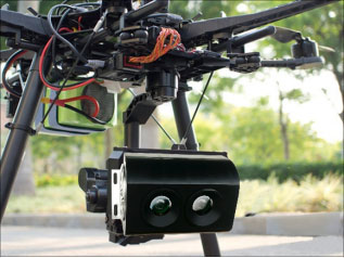
1. Uav visibility meter weighs only 110 grams and is designed for monitoring and collecting meteorological data in the air for unmanned aircraft or small unmanned inspection aircraft;
2. Compact in appearance, with strong anti-electromagnetic interference and dust-proof functions, it can work normally at an altitude of 4,000 meters and an environment of minus 20 degrees;
3. The "four super" visibility meter has an ultra-mini shape, ultra-low wind resistance, ultra-light weight and ultra-low power consumption. The power consumption is only 0.9 watts, making it very suitable for small UAV platforms and flight control systems, as well as environmental monitoring using aircraft;
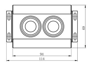
2. UAV visibility meter size and weight
Visibility Dimensions: 94mm * 69mm * 42mm
Visibility + mounting bracket size: 114mm * 69mm * 73mm
Visibility Weight: 110g
3. Main technical parameters of UAV visibility meter
Detection range: 10-4000 meters
Measurement accuracy: ±15%
Light source: IR LED
Response time: 10 seconds
Digital output: RS485, RS232, SDI-12
Bluetooth output: BLE5.0 (optional)
Operating temperature: -20 -50 °C
Working humidity: 0-95%
Supply voltage: VDC 12-24V
Power consumption: 0.9W
4. Uav visibility meter product size and physical picture
Dust detectors serve as vital tools for intelligent management of dust emission pollution, enabling real-time monitoring of dust concentration to provide data support for subsequent management measures.A dust detector can collect real-time concentrations of particulate matters such as PM10 and PM2.5...
Viscosity & Density Sensor utilizes a piezoelectric resonant MEMS core component, integrating high-precision signal acquisition and intelligent algorithms. It can simultaneously measure the temperature, dynamic viscosity, and density of liquids in real time, automatically completing the de...
When it comes to the advantages of water quality sensors, they can be summarized in six words: real - time, continuous, and automatic.Since the sensors can be directly deployed in water bodies (such as rivers, sewage treatment plants, water supply pipe networks, etc.), they collect water quality par...
ambient weather company is a weather station and software manufacturer based in China, specializing in providing customized weather solutions and products for homes and businesses....


 Get a Free Quote
 Skype
Skype
 whatsapp
 mail
mail